Featured Items
- Ken Sanders Rare Books - Featured Items
- Featured items that Ken Sanders Rare Books plans to bring to RMBPF 2018.
- Click on thumbnails to view full-size images.
Featured Items


Description:
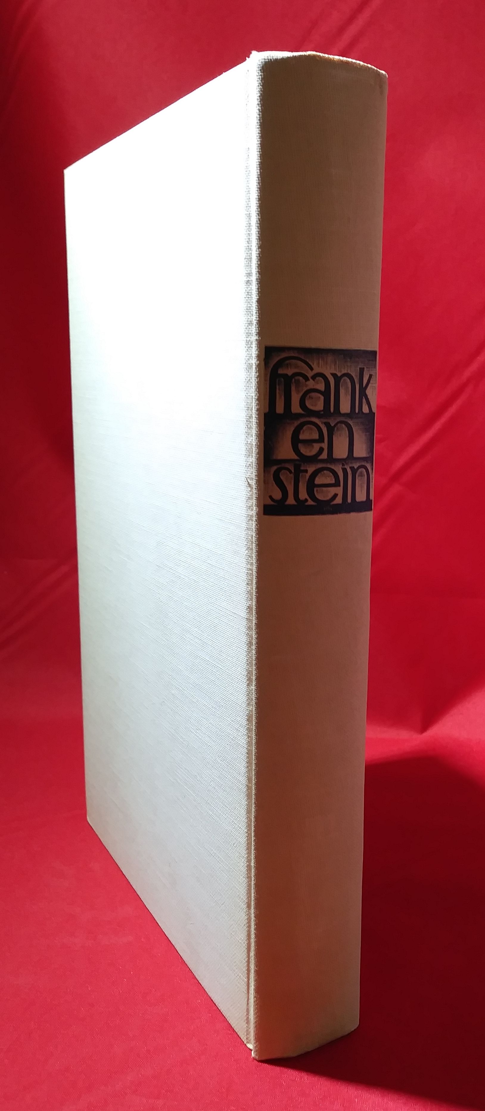
First Edition (Deluxe). 259pp. Octavo [24 cm] in toned white cloth with paper spine and cover labels, publisher's black top stain. Housed in publisher's once-blue board slipcase with illustrated wraparound paper label. Deeper toning to spine, very light smudging to boards, faint bump to front board upper corner, else boards are crisp and unworn; interior is clean and bright. Irregular heavy fading to slipcase, especially at extremities, with cracking and light chipping to open edge; numerous small dampstains and evidence of discreet repair to slipcase at top. Near Fine in Good slipcase. [53520]
Sixty-two illustrations, including fifteen full-page, by Lynd Ward. This is Lynd Ward at the height of his powers, and this gothic novel may be the perfect avenue for his work.
Genre: Woodcuts, Gothic literature
Price $750.00

Description:
Limited Edition. Twenty-five linoleum block prints on Rives paper, each the final printing of an edition of fifty. Prints titled and hand-numbered ‘50/50’ in pencil below image, with the blindstamp of the Southern Utah Wilderness Alliance. Each print includes a “Certificate of Warranty and Authenticity” issued by SUWA and hand-signed by printers Thomas Carlyle and Stuart Steinhardt. The paper dimensions of all but one print are 9.75” x 13”; the remaining sheet measures 8.5” x 9.75”. The block prints themselves vary in size. Stored in mylar sleeves, within a handsome black portfolio. Fine. [52502]
Ruess designed and carved these blocks during the five years before his 1934 disappearance in the Escalante canyons. In 1985, Ruess’ brother, Waldo, found them in a garden shed. Waldo Ruess collaborated with SUWA on this limited-edition printing, which was produced as a fundraiser for the organization. The blocks were donated to the Utah State Historical Society on condition that they never be printed from again. Many of the sets were broken up for individual sale, and no other complete sets are currently on the market.
Price $15,000.00


Description:
Second edition of the 1832 map. Brightly colored fold-out map [29 ¼ x 23"] with states and territories colored by hand. Housed between brown cloth embossed boards. Ex-library, with only brief numerical markings on the front board, front pastedown, and on the verso of the map. Front board professionally reattached. The map is in very good condition, with professional repair to closed tears along the folds, with the majority of them being short, and the longest tear measuring 3". The title printed on the front board states, "Tanner's Travelling Map of Mexico." Ex-libris Californian Catholic priest and book collector, Joseph M. Gleason, with his personalized bookplate on the verso of the front board. [53017]
A remarkably brightly colored example of the important map of the United Mexican States, which played an integral role in the shaping of the U. S. boundary with Mexico. This 1846 Map of the United States of Mexico portrays the United States of Mexico as it was in 1832. With "Tables of Distances," "Statistical Table," and the inset, "Map of the Roads &c From Vera Cruz & Alvarado to Mexico." In Mapping the Transmississippi West 1540-1861, Volume Three (p. 256), Carl Wheat states, "The Southern border of California is shown at 32° west of the gulf, and the Rio Ascension east of it, much farther south than the border fixed by the Treaty, and even farther south than the Gadsden Purchase of 1853-4. The southern border of New Mexico is just north of El Paso. Texas extends to the east bank of the Rio Grande (including Santa Fe) with the long panhandle." Wheat further mentions that the copyright date reveals that the map was hastily prepared in order to capitalize on the Mexican-American War, which was occurring at that time.
Cartographer, Henry Tanner Schenck (1786-1858), was the owner of his own publishing company in Philadelphia. Tanner's Travelling Map of Mexico is the penultimate map of Old Mexico, originally produced prior to the Mexican War, and showing Mexico in all her glory. The Mexican state of Upper California sprawls across the American United States, all the way to Oregon Territory, enveloping all of California and the interior United Sates, including what would become just one year later in 1847, Utah, and briefly, the State of Deseret. The map also bridges the gap between the groundbreaking 1848 map of Fremont's explorations by Charles Preuss, and the first real map of Great Salt Lake City, produced during the Stansbury explorations circa 1850. The Fremont map is largely blank and labeled unexplored country, while the Stansbury map contains wonderful intricate details of the Great Salt Lake, the city, and the Wasatch Mountains. This 1846 Tanner map of Mexico is also wonderfully detailed, with all of the geography present, some even comically erroneous, making this a superb example of an "error map." Not only does the mythical Rio Buenaventura drain "Lake Timpanogos" to the Pacific Ocean, but there are two additional Utah headwater rivers draining to the Pacific. The Colorado, however, is rightfully depicted here as draining into the Gulf of California. Of course, there are no Mormon names assigned to the land yet. Also of note, is the fact that the 1846 edition, dubbed by Tanner as the "second edition," portrays Texas as larger than ever depicted, and furthermore, does not address Fremont's expeditions made between 1842 to 1844. Tanner's map is thus significant for what is mentioned, and what is left out.
Genre: Maps, cartography, Mexico
Price $15,000.00


Description:
First English language edition. [362pp] Folio [36.5 cm] in 3/4 textured maroon cloth over blue boards. Title and bands gilt stamped on backstrip. Printed title on front board. Centimeter-long perforation to spine at foot, numerous small abrasions to rear board, heavy rubbing to boards at extremities; small bookseller's label on each pastedown; interior is clean and crisp; a few short tears to last few plates at foot.
Although the Swedish first edition was also published in 1893, the English language edition of Nordenskiöld's pioneering work on the ruins of Mesa Verde is by far the scarcer edition of the two, and contains over fifty additional pages (primarily illustrative) than does the Swedish edition. [50431]
Nordenskiöld came to the American southwest in 1891 at the invitation of Richard Wetherill, a local cattle rancher, who along with Charles Mason is credited with discovering the Mesa Verde ruins. This collection contains Nordenskiold's notes and photographs of his travels and excavations in the area. The English edition contains many additional plates not in the Swedish edition. The Swedish edition contained seventeen full page plates, this edition contains fifty-one plates. This edition also contains an appendix that was not in the original. The appendix is titled: 'Human Remains from the Cliff Dwellings of Mesa Verde', by G. Retzius. The appendix contains ten full page plates. These large plates include some absolutely exquisite photogravures of the ruins, including the double-page centerfold of "The Cliff Palaces". Also includes 159 smaller black and white illustrations. Full page map present at the rear. The earliest scholarly monograph on Mesa Verde. Mesa Verde comprises some of the most spectacular American Indian ruins in all of North America.
"I shudder to think what Mesa Verde would be today had there been no Gustaf Nordenskiöld. It is through his book that the cliff dwellings of Mesa Verde became known and his volume might well be called the harbinger of Mesa Verde National Park as we know it today." - Robert Heyder, former National Park Superintendent.
Genre: Native American, Archaeology, Western Americana
Price $4,500.00