Featured Items
- Ken Sanders Rare Books - Featured Items
- Featured items that Ken Sanders Rare Books plans to bring to RMBPF 2021.
- Click on thumbnails to view full-size images.
Featured Items


Description:
A rare map of the mining regions surrounding the Great Salt Lake bordered with bold advertisements. Printed at the head of the map: "Zion's Co-operative Mercantile Institution." Zion's Cooperative Mercantile Institution (ZCMI), founded by Brigham Young on October 9, 1868, was the first department store in the United States.
This scarce map of northern Utah is dominated by a bulging Great Salt Lake, with Utah Lake and adjacent areas. In addition, the various mining districts (28 depicted) are bordered in red and named. Furthermore, the map contains four inset city/town plans, showing: Ophir, Alta, Eureka City, Stockton.
The surrounding advertisements, for all sorts of business, hotels, boarding houses, etc, are instructive and entertaining in themselves.
Moffat 110. Wheat 1223.
Condition: Color pocket map [22.4 x 38 inches] which folds into brown cloth boards, titled in gilt on the front board, and with decorative embossing on both boards. Very good. With sunning to the spine, and a bit around the edges. There is a small stain on the rear board, measuring roughly 1" in diameter. Splits along the folds have been professionally and skillfully backed with Japanese tissue. The title on the cover reads, "New mining Map of Utah, Showing 28 prominent Mining Districts And Location of the best known Mines." Pencil name of H. Sill, Ogden, 1876, on the back of the map. In a custom slipcase.:
Genre: Maps, Utah, Western Americana, American West, Froiseth, Mining:
Price: $12500.00


Description:
Arnold Hague's monograph and atlas are still viewed by geologists today as some of the most in-depth studies of Yellowstone to have ever been performed.
Condition: 893pp. Very thick quarto [30 cm] The monograph has been rebound in 3/4 black leather with marbled paper over boards, and matching marbled endpapers. All plates are present, along with the fold-out table. The atlas is an elephant folio [56 cm] in brown cloth over boards, with very skillful restoration work to the backstrip and the lower extremities of the boards. Ex-library (Geological), with only a couple of stamps on the front endpaper (legitimately discarded from the institution). Else, the boards and contents very clean and sharp. A remarkably well-preserved copy. Complete, and in the best condition that we have seen. Will require extra postage due to size and weight.:
Genre: Western Americana, Exploration, Surveys, American West, Hague, Yellowstone, Atlas:
Price: $1500.00

Description:
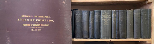
Hayden's monumental survey of the American West, consisting of twelve annual reports, and including the map volume which was issued with the 12th annual report. Of great importance, is the fact that this is the most complete map volume that we have ever seen, with 4 additional maps.
The set is sold together with Hayden's large folio atlas "Geological and Geographical Atlas of Colorado." In this set, the first book is the 1873 reprint which contains the 1st, 2nd, and 3rd annual reports. It is important to note that the 4th Annual Report has the cachet of bearing the bookplate "With the compliments of F. V. Hayden, U. S. Geologist." Flake 9204. Wheat, pp. 344-349.
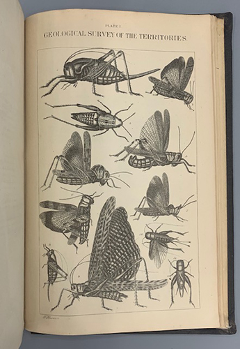
Before Hayden's survey the wonders of Yellowstone and much of the surrounding area was terra incognito and known to only a handful of trappers and a few small bands of Indians. One cannot even begin to imagine the magnitude of the subjects covered in this survey. The treatment that Hayden's group gives the area is massive in its scope, and contains hundreds of plates, maps and graphs charting the geological features as well as the fossil record for the area. Complete sets of this survey are uncommon in any condition, much less with the most complete and definitive collection of maps in the map volume that we have ever encountered.
A set from one of the great surveyors of the American West.
Condition: The volumes are good to about very good. Seven of the spines have been restored with varying amounts of the original backstrips overlaid. Five of the books have had tissue repairs or reinforcement to the hinges. Some of the spine titles are faded. The opening pages have occasional ink stamps. There are cracks in the text blocks here and there (several volumes more prominently: Twelve, Part I and Part II, due to their thickness), but most volumes remain quite sturdy. The front hinges of the 7th and 11th annual reports are broken, and the text block is pulling away from the backstrip of the 7th annual report as well. The volumes which are ex-library have often just a single library stamp. A handful of the maps have sporadic splits along the folds, and minor tape repairs. All plates and illustrations are present, with the exception of just one illustrated plate- Plate 78 in the 10th annual report. The boards of the folio atlas are moisture damaged (rear board more so) and a bit warped. Internally, other than some very faint tide lines here and there, the pages are clean and bright.:
Genre: Western Americana, Exploration, Surveys, American West, Hayden:
Price: $10000.00


Description:
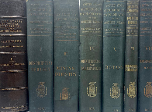
First edition.
Professional Papers of the Engineer Department, U. S. Army. No. 18. Seven volumes plus one atlas. Does not have the general atlas. Quarto [30 cm] Volume 1 is bound in 3/4 leather (with some additional skillful restoration work to the binding), and the remaining volumes are in the publisher's original green cloth. Volume 3 once belonged to The Long Island Historical Society (with deaccession stamp on title page). Volumes 4 and 7 have been professionally rebacked, and the hinges of volume 7 have been expertly reinforced. With moderate wear to the spine and boards, and the underlying boards periodically exposed along the edges of the covers. There are only very occasional cracks in the text blocks. Internally very good with plates having little or no foxing. Several pages have small ink stamps from private clubs and booksellers. Very good.
One of the four major geological surveys of the western United States which took place in the years following the Civil War. This early monumental survey took place in 1867, under the direction of Clarence King (1842-1901). King, a graduate of Yale's Sheffield Scientific School, was only 25 years old when he was appointed Geologist in charge of the exploration along the 40th Parallel, which spanned from Eastern Colorado to California. This expedition represented the first major attempt to map the area in detail, and was one of the first expeditions to use the medium of photography to capture images and activities of the expedition. Timothy O'Sullivan (1840-1882), known for his images of the Civil War, was the photographer for the King survey. His photographs were subsequently reproduced in lithograph form by Julius Bien for inclusion in the published volumes reporting on the expedition. Many of O'Sullivan's original photographs from the 40th Parallel expedition are now in the collection of The George Eastman House in New York and are a unique archive depicting the American West. In 1879, the United States Geological Survey was established and appointed Clarence King its first director. In 1881, King resigned this position to pursue other scientific interests leaving John Wesley Powell (1834-1902) as his successor.
Genre: Western Americana, Exploration, Surveys, American West, Clarence King:
Price: $10000.00


Description:
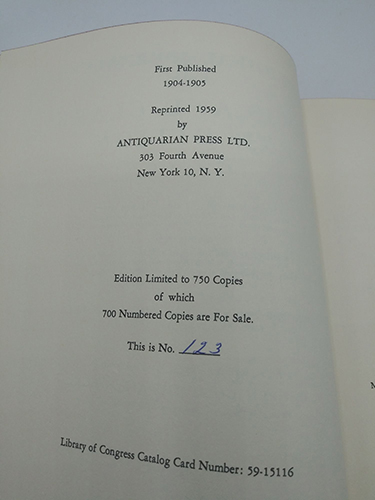
Eight volume set. 374,386,363,372,395,280,534pp. Octavo [24 cm] Full red cloth with title gilt stamped on backstrip. All volume near fine. Eighth volume is a uniformly bound clamshell that contains maps numbered to 54 (appears to be missing Map 22, however Map 22A is present). A very nice set containing the journals and maps of this monumental expedition. This work was limited to 750 sets.
Edition Limited to 750 Copies of which 700 Numbered Copies are For Sale. This is No. 123.
Price: $1750.00